Nanda Devi Sanctuary Trek
Duration 14 Night/15 Days Price 0
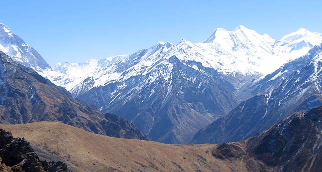
Nanda Devi Sanctuary Trek
The Nanda Devi Sanctuary in the Garhwal Himalayas of India is a unique geographical feature. A ring of peaks connected by massive rock walls which dip no lower than 17,000ft/ 5200 metres forming an impenetrable santuary. The only exception is the point where the river Rishi Ganga which drains this great basin emerges to the west in one of the most spectacular gorges in the world.In this wall of mountains consists of at least twelve peaks over 21,500 ft/ 6500 metres including several famous names such as Changabang and Dunagiri to the North and Trishuli and Nanda Kot to the West and South. This Sanctuary had never been explored by anyone till 1934. The Sanctuary was forbidden for visitors in 1983 in order to maintain the delicate ecology of this hitherto pristine space that needed time to regenerate after the inevitable damage caused by expeditions and shepherds who were also finding their way in.
The Nanda Devi Sanctuary is drained in part, by the Alaknanda and Saraswati rivers. Surveying The Wildlife. The early Indian Surveyors and mountaineers alike were unable to venture into the Inner Sanctuary. It was in 1934 the Eric Shipton and Bill Tilman eventually managed to find their way to the Sanctuary. This paved the way for the Anglo-American mountain expedition of 1936 to ultimately climb the peak. When Tilman and Odell reached the top of Nanda Devi on 29th August, 1936, they had reached the highest point ever climbed by man till then. And this height record stood till the French stood on top of Annapurna in Nepal in 1950 - the first 8,000m peak to be climbed by man.
Package Itinerary
Day 01: Rishikesh to Lohajung (285 kms / 10 hrs)
Early morning drive to the small hamlet of Lohajung (2213 m), from where the trek begins.Overnight: Lodge
Day 02: Lohajung - Didina
2439 mts / 06 hrs walk-In the morning our team of porters will arrive and we will set off on the first stage of our trek. We have a steady climb up to the Lohajang Col at 2590m which we cross to reach the valley of the Bedni Ganga. We descend on the north side of the pass down to the river before climbing back up to the little village of Didina (2439m) where we camp.Overnight: Tent
Day 03: Didina - Bedni Bugyal
Today is a steep trek through oak trees and large stands of bamboo up to Ali Bugyal. From here we can enjoy an expansive view of the Garhwal peaks. We continue trekking through thick forests as far as Bedni Bugyal (Bugyal means meadow in the local Garhwali dialect). Very occasionally the brown Himalayan bear can be encountered on this section of the trail, but it is an elusive animal. From Bedni Bugyal we have an excellent view of the various summits of Trisul (7120m) and the peaks of the north of Garhwal. Bedini Bugyal is a charming green meadow adorned with a myriad of colourful flowers. There is a lake situated in the middle of the meadow where Hindu pilgrims come to bathe, and nearby is a small temple.Overnight: Tent
Day 04: Bedni Bugyal
Rest day at Bedni Bugyal for acclimatization - Overnight: Tent
Day 05: Bedni Bugyal - Baguabasa (4100 m)
After 2 hours of gradual climb up, uninterrupted views of Trisul range and Nanda Ghunti can be appreciated. The trail crosses a hump to reach Bistola and then climbs up to Baguabasa, an improvised stone shelter that is generally used by local pilgrims.Overnight: Tent
Day 06: Baguabasa - Roop Kund
(5029 m) and back to Baguabasa- Stupendous views of Trisul and the mountains around. An arduous and spectacular trek for about three hours gets us to Roop Kund, a holy lake surrounded by glaciers and high peaks and situated on the outer rim of the Nanda Devi Sanctuary. Every 12 years thousands of devout pilgrims, carrying a golden idol of the goddess Nanda Devi, undertake a difficult trek to this holy lake from Nauti village, near Karnaprayag.Overnight: Tent
Day 07: Baguabasa - Wan (2450 m)
Return trek to Badni Bugyal. The trek then makes a long, steep descent through a fine forest of firs and rhododendrons and across a beautiful clearing with much of the track being paved. After crossing a river, a short climb leads to the main valley, at the head of which is Wan.Overnight: Tent.
Day 08: Wan - Kukin Khal Pass (2900 m) - Sutol (2200 m)
Walking on past Latu's temple the path climbs gently up through magnificent cypress trees. After the pass the path drops down to broad meadows. The village of Kunol (2650 m) is set in an idyllic location with stunning views of the high peaks north of Josimath. Above the village rhododendron trees remain in full bloom from april until beginning of june. Further down the trail is lined with orchids and luxuriant ferns as it passes through one of the finest mixed forests in Garhwal.Overnight: Tent
Day 9: Sutol - Ramni (1982m)
The trek now traverses along the valley with a number of ups and downs and huge drops down to the river gorge below, through forests smelling of fir trees. After dropping to a river, crossed by a green girder footbridge there is a long steep climb to a little temple followed by a gradual climb through forest to emerge near farms and fields, on a ridge with amazing views of Trisul. Ramani, a fairly big village.Overnight: Tent
Day 10: Ramni- Jhenjipani
(2015 Mt)-13 km trek from Ramni to Jhenjipani. A good zigzagging track leads to open grassy grazing meadows. Snow peaks begin to emerge above the forest to the north. We then begin to climb steeply as the path moves diagonally through forests of rhododendrons, pines and holm oak with more pastures and shepherd huts.Overnight: Tent
Day 12: Jhenjipani- Sinyartoli
(2043 Mt)-12 km trek from Jhenjipani to Sinyartoli. The trail carries on down past small farms, through woods, to the spectacular suspension bridge across the Brithi Ganga gorges. After a very steep climb the path is almost flat, passing through fine rhododendron forest, with many streams and waterfalls.Overnight: Tent
Day 12: Sinyartoli - Dhakwani
(3200 m)-10 km trek Sinyartoli to Dhakwani. This is a long, but spectacular day. The route starts a steep climb up into rhododendron forest, then descends gently to open meadows with views across to the Kauri Pass, and finally plunges down a very steep section to a river. From there a final climb brings us above the tree-line to large pastures. Overnight stay tent.Overnight: Tent
Day 13: Dhakwani
Tali via Kauri Pass (4268 Mt)-12 km trek Dhakwani to Tali via Kauri Pass. The climb up to the pass is made on a zigzag track to the top. From the pass the Himalayan summits seem to be arrayed before us in a stupendous arch. It is often said that this is one of the greatest mountain views in the world. Overnight tent.
Day 14: Tali - Auli (2519 Mt)
Drive to Rudraprayag-14 km trek from Tali to Auli (a popular skiing zone in India). Arrive Auli and after spending sometime there, you will be driven to Rudraprayag.Overnight: Hotel.
Day 15: Rudraprayag - Haridwar/Rishikesh (175 Km / 6 - 7 hrs)
After breakfast drive to Rishikesh. Upon arrival at Rishikesh tour end.
Inclusions
Exclusion
how to reach Rishikesh
Places to Visit In Rishikesh
- Anand Prakash Ashram
- Andhra Ashram
- Bharat Temple
- Geeta Bhawan
- Himalayan Yog Ashram
- Jumpin Heights
- Lakshman Jhula
- Lakshman Temple
- Madhuban Ashram
- Neelkanth Mahadev Temple
- Neer Garh Waterfalls
- Nirmal Ashram
- Omkarananda Ashram
- Osho Ganga Dham Ashram
- Parmarth Niketan
- Phool Chatti Ashram
- Raghunath Temple
- Rajaji National Park
- Ram Jhula
- Rishikund
- Sadhaka Grama Ashram
- Shatrughna Temple
- Sivananda Ashram
- Swami Dayananda Ashram
- Swargashram
- Tera Manzil Temple
- Triveni Ghat
- Vanprastha Ashram
- Vashistha Cave
- Virbhadra Temple


